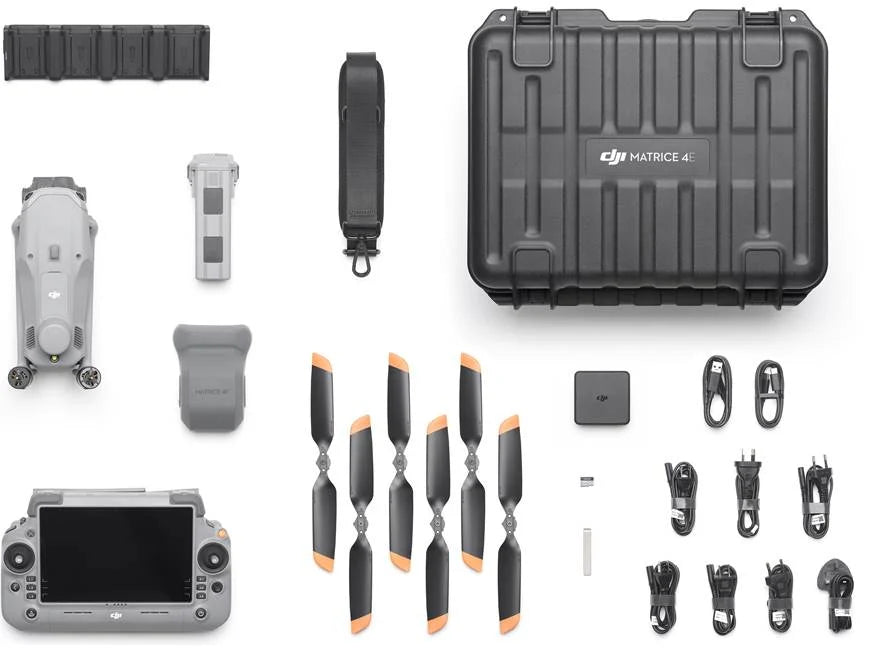
In the Box

  • M4E Mission Ready Package

    • 1x DJI Matrice 4E Drone
    • 1x RC Plus 2 Enterprise Remote Controller
    • 4x Flight Batteries
    • 1x 200W USB-C Power Adapter
    • 1x Battery Charging Hub
    • 1x Gimbal Protector
    • 3x Pair of Extra Propellers
    • 1x 100W Power Adapter Cable
    • 1x USB-C Data Cable
    • 1x USB-C to USB-A Data Cable
    • 1x Storage Case
    • 1x Storage Case Shoulder Strap

  • M4E Essential Package

    • 1x DJI Matrice 4E Drone
    • 1x RC Plus 2 Enterprise Remote Controller
    • 1x Flight Battery
    • 1x 200W USB-C Power Adapter
    • 1x Battery Charging Hub
    • 1x Gimbal Protector
    • 3x Pair of Extra Propellers
    • 1x 100W Power Adapter Cable
    • 1x USB-C Data Cable
    • 1x USB-C to USB-A Data Cable
    • 1x Storage Case
    • 1x Storage Case Shoulder Strap

DJI Matrice 4E

DJI Matrice 4E – Precision Mapping & Surveying Drone

At TerraXplore, we deliver cutting-edge DJI Enterprise solutions built for professionals who depend on accurate, reliable aerial data in the field. The DJI Matrice 4E is engineered specifically for geospatial and mapping professionals, offering a powerful combination of precision, efficiency, and ease of use for demanding survey and modeling workflows.

Applications

Surveying & Mapping: Perfect for surveyors, engineers, and government agencies requiring precise aerial data for land measurement, planning, and geospatial analysis.

Construction & Site Development: Create accurate 2D maps and 3D models to support project planning, monitoring, and infrastructure development from start to finish.

Infrastructure & Asset Inspection: Safely evaluate bridges, buildings, and other critical structures using high-resolution imaging without putting personnel at risk.

Max Flight Distance:15.5 Miles

Max Flight Speed:47 mph

Max Wind Resistance:26.8 mph

49 Minutes

Max Flight Time

Specifications

Technical Specifications

DJI Matrice 4E

The DJI Matrice 4E is a compact enterprise drone designed for surveying, mapping, and inspection operations. It combines high-precision imaging, stable flight performance, and rapid deployment into a streamlined platform built for efficient, mission-ready data collection in professional environments.

Battery

The DJI Matrice 4E features a high-efficiency intelligent battery system built for extended enterprise missions, offering up to 49 minutes of flight time under ideal conditions. Its advanced power management system delivers real-time battery health monitoring, optimized energy use, and enhanced operational safety—enabling longer, more reliable missions with minimal downtime and fewer interruptions in the field.

Transmission

The DJI Matrice 4E is equipped with DJI O4 Enterprise transmission, providing a stable, low-latency live video feed with strong resistance to interference. With a transmission range of up to 25 km (FCC), it ensures dependable long-distance control and real-time situational awareness, even in demanding industrial or urban environments.

Safety

The DJI Matrice 4E is equipped with an omnidirectional obstacle sensing system powered by a network of vision sensors, delivering comprehensive awareness of its surroundings in all directions. This intelligent detection system identifies obstacles in real time and supports automated braking or avoidance maneuvers, helping ensure safer low-altitude operations during inspection, mapping, and other precision flight missions.

WHY THE M4E

Built for Operators Who Need Accurate Data

The DJI Matrice 4E is DJI's most capable compact mapping drone — purpose-built for field boundary surveys, drainage analysis, and precision agriculture data collection.

⏱️

Up to 49 Minutes Per Flight

The M4E's extended battery life lets you cover more acres per takeoff — fewer battery swaps, less downtime, and more data captured before the end of the day.

📡

1cm RTK Accuracy

Integrated RTK with D-RTK 3 base station support delivers 1 cm + 1 ppm horizontal accuracy — no GCPs required for most survey-grade agricultural deliverables.

🗺️

5-Direction Oblique Capture

The M4E captures nadir, forward, backward, left, and right oblique frames in a single automated pass — delivering complete 3D field models without a second flight.

📱

DJI Pilot 2 App

Plan missions, monitor RTK fix status, and manage field data all from the RC Plus 2 controller. One screen handles everything from pre-flight to post-processing handoff.

🛠️

Parts Always In Stock

TerraXplore stocks M4E replacement parts and accessories. A broken prop or dead battery never has to mean a lost field day when you buy from us.

🏅

DJI Authorized Dealer

Buy with confidence. As a DJI Authorized Dealer, we sell genuine hardware with full manufacturer warranty and official support — no gray market risk.

COMMON QUESTIONS

M4E FAQs

What's the difference between the aircraft-only M4E and the Precision Mapping Bundle? +

The aircraft-only M4E is for operators who already own RTK infrastructure or plan to use network RTK via NTRIP. The Precision Mapping Bundle includes the aircraft, RC Plus 2 controller, 4 batteries, D-RTK 3 base station, survey pole and tripod kit, storage case, and a pre-activated 1-year DJI Terra license — everything you need to fly a survey-grade mission on day one without any additional purchases. Not sure which fits your setup? Call us at (515) 802-0465.

Do I need a license to fly the M4E commercially? +

Yes. You need an FAA Part 107 Remote Pilot Certificate to fly commercially in the U.S. For survey deliverables that require a legal stamp — property boundary surveys, for example — you'll also need a licensed surveyor to certify the data. The M4E handles the data collection; professional certification is a separate step handled by the surveyor of record. Every TerraXplore purchase includes a full Regulations Package covering FAA requirements and operational guidance.

Do I need DJI Terra, or can I use a different mapping software? +

DJI Terra is the recommended platform and integrates directly with the M4E's RTK data and factory camera calibration. That said, the M4E is fully compatible with third-party photogrammetry platforms including Pix4D, Agisoft Metashape, DroneDeploy, and Bentley ContextCapture — all of which accept M4E imagery with embedded RTK position tags. If you purchase the Precision Mapping Bundle, a 1-year DJI Terra Pro license is included at no additional charge.

What warranty does the M4E come with? +

The M4E comes with a 12-month limited warranty on the airframe, gimbal, camera, RTK module, RC Plus 2 controller, and core electronics. Battery warranty covers 12 months or 200 charge cycles, whichever comes first. Because TerraXplore is a DJI Authorized Dealer, your warranty is registered directly with DJI — you get full manufacturer support, not a gray market workaround. Full details are on our Warranty page.

Can I trade in my current drone toward an M4E? +

Absolutely. TerraXplore accepts any make and any model drone as a trade-in toward a new M4E, T100, LD220, or T60X. Fill out the trade-in form and we'll send you a valuation within 1 business day. Most trade-ins are valued between $2,000–$15,000 depending on make, model, age, and condition.

How long does shipping take and is it really free? +

Yes — completely free shipping anywhere in the U.S., no minimum. In-stock units ship within 1–3 business days. You'll get a tracking number as soon as your order ships. Need it faster? Call us at (515) 802-0465 and we'll see what we can do.